Thursday, May 30, 2019

SNETT

Since I happen to have a bike that is better suited for roads not covered with asphalt, I've been searching for more such places to ride around Boston Metro area. So far, in search of the unpaved, I mostly visited locations north and west of Boston. The last weekend I decided to change that and try a trail in the south - the SNETT.

SNETT stands for the Southern New England Trunkline Trail. It's a path built in place of a former railroad, running from Blackstone, MA to Thompson, CT. Because I didn't want to just ride the same trail there and back, I decided to create a loop that would take me through three states: MA, CT and RI.

I started in Blackstone, where I left my car. Then I followed the paved Blackstone River Greenway to the end where it becomes unpaved and turns into SNETT. Actually, it's a bit difficult to navigate around the way these two trails merge. There is a section running alongside Rt146 - a busy highway, but eventually I was able to locate a path entering forest.
Unfortunately, this is where likely the worst part of the whole route was. We had a severe thunderstorm the night before and trails were still wet. The first section of SNETT was flooded and extremely muddy. I was moving forward very slowly, often walking on the trail's shoulder, trying to figure out how deep these puddles really were. I think memories from the previous year were still fresh, when I was going through Catamount State Forest and decided to just ride through the mud, only to spend the next half an hour pouring mud and water out of my shoes and trying to make myself somewhat presentable.
Fortunately, the rest of SNETT was in a better shape and I could pick up some speed. Just like many rail trails around, SNETT is flat, straight and... somewhat boring. In fact my initial impressions were not great and I thought that for someone who lives in that area, this trail would certainly be useful, but I wouldn't recommend to plan a whole day trip there just to ride on SNETT. Actually, the Rockingham Recreational Trail I visited not too long ago seemed much more interesting.
The good thing is that this changes once we get closer to Douglas State Forest. Here's where we find a more variety in scenery - from ponds, lakes, streams to wetlands and wildlife surrounding the trail.
In fact, I would say that if you happen to be in the area, it's likely worth parking in either Douglas, MA or East Thompson, CT and checking out that section of SNETT.
After spending the first 30km (18mi) on SNETT, I decided to head back but riding on main roads certainly isn't my kind of fun. I went south, into Rhode Island, to cross Buck Hill Management Area and find my way back east.
The path across was an ATV trail - rocky and sandy in places, but accessible by a mountain bike. From there I followed local roads to Black Hut State Management Area, which had trails of essentially the same kind - more rocks, more sand and more roots. And some fallen trees once a while. Both places looked pretty abandoned. It didn't look like they get many visitors in a year.
After 4hrs and 40min. I was back at my car in Blackstone. It turned out, I was there in likely the last possible moment to leave the town. It was Memorial Day and several blocks around Main St were already blocked off by police for the incoming parade. Had I made my ride any longer, I might've been stuck in Blackstone and unable to leave until the end of parade.

Wednesday, May 29, 2019

Boxford to Georgetown

The long May weekend is behind us. Weather was pretty decent, which means at least it wasn't raining, but unfortunately, it was way too sunny for may taste. I explained previously why cloudy and cool weather is best for bike riding. This wasn't the case the last weekend.

Still, I couldn't just sit at home the whole time. I decided to ride a quick loop around Boxford and Georgetown, starting in North Andover at Harold Parker State Forest (HPSF). If you live in this area, you know this place well, I'm sure. It's a very popular spot for mountain bikers, with plenty of rough forest trails to explore.

I visited HPSF multiple times before, but I've never tried to drive there. It's relatively close to my house so usually I just bike there directly. This time however, since I wanted to go further north, in order to save time I drove to the park and decided to leave my car there. I was surprised that it costs $5 for a day pass to park in HPSF. Either it's a new thing there, or I completely missed that before. Anyway, it's not a big deal. I'll gladly pay a fee, if it helps protecting the few remaining large forested areas in our suburbs.


I followed the main road towards Stearns Pond, passing several mountain bikers on the way. My goal was to make my way further north towards Boxford.
I was positively surprised by Boxford State Forest. It's smaller than HPSF but at the same time it's less crowded. There is a network of trails running through the forest and most of them are relatively rocky. In general, a bike with wide tires is preferred. I rolled on 2.2" wide Maxxis tires but if you come here with your gravel bike, you will likely do just fine.
A good chunk of my route followed the Bay Circuit Trail. This is a hiking trail that runs all around the Boston Metro area from north to south. The trail is quite long and I was thinking about riding the full length of it at some point. This would require camping somewhere on the way but such options are relatively limited in Boston's suburbs. I need to figure out whether that's actually doable.
The last larger forest I visited on my way was Georgetown-Rowley State Forest. It's much more remote than the first two, so I didn't see anyone when riding through it. Seemed like I pretty much had the whole forest for myself.
On my way back I used a shortcut via Brook Street in North Andover. This road is closed for cars as it's frequently flooded by wetlands on both sides. As a result, it's quiet here and wildlife can flourish. I ran into a heron sitting in the middle of the road. Looks like I need to remember to bring my telephoto lens the next time. I could only get so close to the heron before he got scared and flew away.
The real fun however, starts when you get to the Mary French Reservation just off Korinthian Way in Andover. There is a single trail running across those wetlands and is all on a boardwalk - one of the longest and narrowest boardwalks I know around Boston. It continues in a tall grass across the open area and then into the forest. It can certainly be crossed by bike as long as you have a somewhat decent sense of balance.
It took me 3.5 hrs to complete this 30-mi route and I'm glad there are still places like these around Boston. In this highly urbanized area, it's difficult to find nice places to ride, away from crowds, away from cars and somewhere in nature.

Tuesday, May 14, 2019

Exploring New Hampshire - Rockingham Rec Trail

I think this rain will never end. Not counting a few breaks, it's been raining roughly since early April. For some of you it may not matter, but I somehow never really submitted to cycling in rain. I just don't find it enjoyable in any way.
 
Nevertheless, last Sunday I really wanted to spend a day outside and explore some places in southern New Hampshire. Of course, the moment I left my house it started raining heavily. I quickly checked the forecast for Manchester, NH and it showed a heavy overcast but no rain. I decided to chance it.
 
Rain followed me all the way to New Hampshire border but then, when I approached Merrimack, a miracle happened - it stopped raining and soon I noticed that highway was completely dry - a good sign that heavy rains on that day must have been only happening in Massachusetts.
I left my car at Rt 101 and quickly hopped on the bike. My plan was to explore the full length of Rockingham Recreational Trail from Auburn to Newfields, then ride back through Pawtuckaway State Park and Bear Brook State Park. It's a pretty long loop, about 70mi (113km), so I anticipated it would take me almost the whole day.
I bet the trail is quite popular on warm, summer weekends but since the day was cool and cloudy, I didn't see many people that day. In fact, the whole day turned out to be perfect for bike riding but not so great for picture taking. Heavy overcast made the sky white or grey in all pictures. On the other hand though, air temperature was only 50-60F (10-15C) and that's what I like on long rides. I don't need to worry about overheating, sunburns and I don't get tired too quickly.
The Rockingham Recreational Trail was built in place of a former railroad and as such, is very flat so you won't find any steep grades there. But there are a few underpasses where the trail is crossing major roads. These were built in form of narrow tunnels. Interestingly, they are also very, very low. So low, that in places one needs to be very careful not to hit head when sitting on bike.
A large portion of trail runs through and alongside wetlands. Swamps and marshes surround it on all sides. I actually like it a lot since it adds some variety to otherwise straight and flat road.
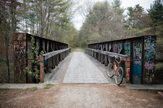
In some places, the trail crosses small rivers and streams using rusty railroad bridges.
The closer I was getting to Newfields in the east, the more remote the trail was getting. I was meeting fewer and fewer people on the road and eventually, I reached a defunct railroad depot and a small parking lot - the eastern terminal of Rockingham Rec Trail.
 
After rolling on gravel for the last 25mi (40km), it was time to merge now with a paved road and make my way back west. I quickly realized how spoiled I got riding on a rail trail. The road ahead was maybe paved, but it was also hilly and required some climbing. This is one thing you can always be sure when you ride on a rail trail - it will be very flat, since trains that used it in the past would have never made it up a steep grade.

Another 15mi later, I finally entered Pawtuckaway State Park and road became unpaved again. In fact, it quickly got very rough and rocky and I was glad my bike had wide tires to handle that.
Pawtuckaway Park is certainly a popular place. Despite less-than-perfect weather, the park was full of visitors and I had to share trails with hikers and roads with cars.
The situation was completely different when I got to Bear Brook State Park. This place was empty. I didn't find anyone hiking the trails and I had Podunk Rd all for myself.
It took me about 7.5 hrs to ride the full length of this route, including all stops. When I finished, I was very hungry.
 
I managed to record the ride this time and not run out of phone battery (The trick is to download the map for offline use and put cell phone in airplane mode for the whole time). I was surprised later to find out that GPS measured my top speed at 72km/h (45mph), but that's quite possible, given some very long and steep hills around Nottingham and Deerfield.
When I got back to Massachusetts, it was still raining. I guess this means I picked a good day to spend it across the state border. And I deserved a beer...

Tuesday, May 7, 2019

Too little, too late

Have you ever heard about these things called gravel bikes? Apparently, these are a special kind of bicycles that you need if you ever want to leave a safety of pavement and feel adventurous enough to explore those untamed dirt roads. Well, at least that's roughly how these bikes are marketed to road cyclists.

Nevertheless, it's a trend and gained huge popularity. More and more people don't want to ride on roads anymore for a variety of reasons - whether it's the necessity of "sharing" the space with speeding cars, boredom of counting potholes in asphalt, or a feeling of requirement to look like Lance Armstrong in Tour de France.

It's 2019 and now pretty much every bicycle manufacturer offers a "gravel bike" in their catalog. There's a problem though and it's the gearing. You see, bicycle components that are supposed to work well with drop handlebars were originally developed for racing road bikes. As such, shifters and derailleurs were built to handle modest gearing ranges and more importantly, high gearing with very limited low gearing options. 

Gearing of a typical racing road bike with 25mm wide tires, 50/34T crankset and a 11-30T cassette offers range from 30 to 122 gear inches. I won't go into details what gear inches are, but basically, it's enough to know that more means a "harder" gear - faster, but requiring more power to spin the cranks. Few ordinary mortals (non-racers) would ever be able to spin cranks fast enough to use those 122 gear inches effectively. In fact, I bet that many smallest cogs in road bike cassettes remain unused, as very few average Joes need such a high gearing. They would likely be much, much happier with 22-100 gear inches of range.

Unfortunately, this is basically what we had to go with if we wanted to ride a bike with drop bars - simply because there were very few options for road-compatible cranksets that could handle smaller chainrings.

Trek Checkpoint - a gravel bike with road racing components. In my opinion way too over-geared for an average Joe.
 
On top of that, gravel bike wheels are typically larger than road bike wheels, since they run wider tires, which means that the same road component groupset installed on a gravel bike results in too high gears. Yet another example how out-of-place those road components were on gravel bikes.

As such, gravel cyclists started to move to 1x setups with a single front chainring and wide-range cassettes to combat this issue. There were few truly low 2x road gearing options available.

Not anymore.
Today, Shimano - the largest bicycle component manufacturer, finally joined the XXI century by introducing GRX - their "gravel" groupset. However important this is for us - average mortals, unfortunately, I feel that this move is still too conservative and offers too little, too late.

First of all, there's no 12-speed option, in time when everyone is moving to 12 speeds for MTB and road. That's probably ok for now - not everybody needs 12 speeds.

Then, there are the cranksets: 48/31T and 46/30T. That's all good. These are much more useful gearing ranges than the road compact 50/34T, which required superhuman abilities to ride uphill. Still, why not give us more choices? Where is the 42/26T for example?

Finally, Shimano didn't show any new cassettes, which means they expect us to pair the new components with their existing 11-32T and 11-34T cassettes. Why not introduce something like a 10-44T or 10-46T cassette, based on the existing Microspline standard?

Other minor issue I have with the new groupset is what I complained about a lot in the past - it only comes in black. I guess classic polished silver is a thing of the past and is not coming back.

In general, I think that the new GRX is a welcomed addition to Shimano component line for three main reasons:
  1. It's coming from the large manufacturer who finally decided to recognize a global trend.
  2. It will help to end dominance of the silly race-oriented gearing in amateur, recreational road bikes. An average Joe won't be struggling riding uphill anymore.
  3. It will appeal to all those "gravel" folks who like to race. For them, the new gearing range offered by GRX is likely close to perfect.

For me, this would be great maybe... 5 years ago. Since then, I have moved towards even lower gearing, rougher roads and trails. Now I want Shimano to simply make their road and MTB groupsets compatible so I can mix and match components as much as I like. I want to use MTB rear derailleur with STI shifters and road cranks. Seems that I may have to wait another 5 years for it.

Thursday, May 2, 2019

Lazy bike lanes

Sometimes I have a chance to revisit places I've been to long time ago. It's fun to find out what has changed, what's new, what's gone. One of the things that I immediately notice in my neighborhood are new bike lanes. The fact that they pop out more often makes me happy, but at the same time their design makes me mad as hell.
 
That's because we seem to be getting mainly two types of bike lanes in America. The first type is a "paint-protected" bike lane. It has a buffer, painted on the road, but no physical barrier separating cyclists from fast-moving car traffic:
The second one is a door-zone bike lane. It's a lane "built" with just two stripes of paint, between parked cars and speeding vehicle traffic:


Both designs have essentially the same flaws. Since paint protects only from corrosion, it's pointless to designate space for bicycles on street, if that space gets often blocked by parked cars, which, as a result, force cyclists to go around them and move into the traffic lane. Basically, drivers see such bikes lanes as a convenient place to pull over, park for a (longer) while or unload their truck. Even police doesn't seem to care and parks in these lanes frequently.
 
But what really pisses me off is that such design simply shows how motivated our politicians are to protect drivers' convenience over protecting people's lives. Bike lanes painted on the wrong side of parked cars (from the traffic lane and not the sidewalk side) benefit drivers, not cyclists. They serve as a convenient buffer (no-traffic zone) when exiting a car. At the same time though, they place cyclists between a speeding traffic and swung-open doors of parked vehicles.
 
These lazy bike lanes are also very cheap to "build". All you need is a bucket of paint. As such, a local governor who approves such design sends a message - "I don't give a shit about cyclists. Here, this is a bike lane. You got what you wanted. Now, piss off".
 
Somehow, I feel that whoever approves this crap should be forced to bike-commute there everyday, including his/her (grand)children.
 
Just recently bike-commuters all across the United States proved how bad such designed lanes are by placing red cups in the buffer zone, where you would normally expect a solid barrier. Not surprisingly, most of the cups were quickly crushed under wheels of cars ignoring these buffer zones completely.
 
So there you go - we need more bike lanes but not just any lanes. They absolutely have to be properly designed, otherwise they are only a little better than sharrows. Unfortunately, there are plenty of NIMBYs in every neighborhood who are ready to fight any changes and will often oppose removal of a single parking spot to make space for bicycles.
 
Cambridge, MA made a move into the right direction thanks to its mayor (and a whole lot of activists), who understands that human life should come first, even if it means losing a few parking spots.
 
Unfortunately, just across the river, in Boston, things are much less rosy pink. While councilor Michelle Wu proposed ending giving residential parking permits for free, like candy on Halloween, mayor Walsh quickly objected that "charging somebody who lives in the city of Boston for a parking sticker to park on street, just isn't fair." Wu's proposal was actually very modest. She wanted to raise the cost of annual parking permit from $0 to $25 for the first car and by an extra $25 for every additional one. To be fair, this still sounds ridiculously low, but it's a start. By my take it should be at least $100-250 for the first car (per year), much more than that for the 2nd and more than 2 cars per household shoudn't be even allowed!

Of course, this wouldn't make people like #FiveCarFlaherty, or actually Michael Flaherty - councilor in Boston, happy. He admitted to own 5 cars and is scared he would have to pay $375 per year to park them. Many people quickly pointed out the idiocy in his words:


But, I guess it's easier to blame too many bus stops for parking problems than notice that Boston's streets have limited capacity, especially if you're trying to park 5 cars per household on them.
 
Meanwhile, it's raining again. Brilliant. I read that today Boston had the coldest weather in the entire United States - even worse than northern Maine or Fairbanks, AK. This (and lousy bike lanes) won't stop me from riding my bike though.