Wednesday, May 30, 2018

My own D2R2 - climbing, more climbing and... swimming

It's the gravel race season! Trans Iowa is already over. Dirty Kanza starts this Saturday. But if you're looking for something more local, you will have to wait until August for Deerfield Dirt Road Randonnee, better known as D2R2 that happens around Deerfield, MA.
 
After riding the course of Kearsarge Classic two years ago, I said that "D2R2 will be next". The only problem is that I don't race and I really didn't want to wait until August. Which is why I decided to ride the course of 2017 D2R2 100k event on this year's Memorial Day.

It all started early at 5:30AM when I left my house and drove for almost 2hrs to eventually reach Greenfield, MA. It was raining, so I expected all roads to be wet most of the day, but at least it wasn't supposed to rain later on (and it didn't). Since the sun didn't break through clouds until late afternoon it was warm but cloudy - a perfect day for bike riding. If only it wasn't so humid...

The first problem I encountered right in the downtown Greenfield was where to park for the day. Most parking lots have a 4-hour limit and the same applies to on-street parking meters. Fortunately, I was there on Memorial Day and since all meters are free on holidays and Sundays, my problem was solved.

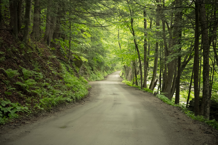
The first miles were a bit boring and fun didn't start until I reached Green River Rd around mile 7 (11km mark). The next 8 miles (13km) passed quickly since I was rolling on a wide, unpaved "highway". The Green River Rd runs along Green River under a full canopy of trees and is certainly a very nice place for a bike ride. I imagine it must look even better in the peak of fall foliage season. But at the same time, it's flat. It so easy that even your aunt could do it. On a Hubway bike. Wearing flip-flops.
These were just the first miles and I still hoped that the rest of the course would be a bit more... adventurous. Soon, road conditions changed and once I got to the Vermont border I entered a forest road (Abijah Prince Rd) that quickly turned into a rough doubletrack.
Finally, I reached the famous Green River Covered Bridge to continue further into Vermont.
Next I climbed Deer Park Rd, making my way up slowly its 11% grade. There was very little car traffic on the road and maybe that's why a large, black bear decided it was a good moment to cross the road about 70ft (20m) in front of me. Hoping that he's not going to hang out at the edge of the road and wait for me, I proceeded slowly,... singing. I guess here is where all those ultra-noisy rear hubs come handy. You simply notify all wild animals that you're coming!
It was close to 11am but still very foggy and humid. Fortunately, the next part was a steep downhill along Jacksonville Stage Rd so I could cool off a bit.
That rest was much needed, as the next part was a mad climb on 18% grade Pennel Hill Rd. I was happy I built my bike with a super low gearing of 26T/32T. Soon, I was back in Massachusetts and since after every tough climb comes a rewarding downhill, I think I broke a sound barrier on Ed Clark Rd.
So far my route followed D2R2 2017 100k and 115k routes pretty much exactly, but once I got to Adamsville I made some changes. First, I wanted to visit Shelburne Falls on my way, which was omitted along the original D2R2 route. I also felt like D2R2 ran on too many paved roads for my taste, so I wanted to include more offroad riding.

For that purpose, I decided to go across Catamount State Forest, which seemed like a great unpaved shortcut to Shelburne Falls... and what turned out to be a catastrophic mistake.
The beginning of the trail was rocky and slippery from all the wet leaves but it actually turned out to be ride-able later on. I was slowly moving forward and thought that I was going to make it to Shelburne Falls pretty soon.
But then I found out that my trail was flooded. It looked too deep to ride through it so I had to do a fair amount of bushwalking (like literally walking through bushes) but I made it across with dry feet.

Then it only got worse. A bit further down the road, trail was flooded again and resembled a small lake. I didn't see any way to get around it so I had to take my shoes off and try to walk through it.
That didn't go well. Water was so deep that not wanting to end up waist-down in it, I had to bail out. I found a narrow ledge along this "lake" that I could use to get to the other side.

Unfortunately, that wasn't the end of it. The last flooded section didn't look that deep so I decided to ride through it. Big mistake. I got stuck in the huge puddle of mud and spent the next half an hour trying to empty mud out of my shoes and clean up at least a little. I guess that was the adventure I asked for.
All this means that if you get an idea to ride your bike there - just slap yourself in the face and find something better to do. Seriously.

The good thing was that the rest of this road was just smooth sailing, if you can describe a very rocky mountain-bike-only trail this way.
I got to Shelburne Falls hungry and wet so I stopped at Hearty Eats (highly recommended!) for lunch. It must've been the food that kept me going since the next miles all the way to Deerfield passed pretty quickly. I know that I cheated a little bit skipping climbing on Patten Rd, which is a part of the original D2R2 course (I chose to visit Shelburne Falls instead) but honestly, traversing Catamount State Forest was much more challenging than that.

In Deerfield, the sun was out, sky turned blue and I quickly realized how lucky I was not having to ride the full 100km in scorching sun. I'll take a cloudy day anytime!

I didn't stop in Deerfield but the historical center looks interesting and cute. Probably worth another, separate visit.
Overall, I found D2R2 route a bit challenging but not due its technical difficulty (there is none), but its length and amount of climbing. I would probably design the route differently, but then you would likely need to wear fishing waders on your bike.

Best D2R2 100km time: about 3hrs 30min.
My time: 8hrs (6hrs riding, 1.5hrs "swimming", 30min lunch).

Friday, May 18, 2018

It's the Bike To Work Month so I took a day off to bike

Today is the Bike To Work Day in the middle of Bike To Work Month. Sometimes I wonder why May is supposed to be the month when we should all bike to work? It must be about weather (which isn't that great in May anyway), because it can't be about the great bicycling infrastructure that suddenly appears overnight on May 1st and disappears on May 31st. If anything, the little infrastructure we get quickly disappears under wheels of parked cars. Bike lanes are the new free parking spots - didn't you get the memo?

Anyway, we had a company safety meeting recently and in one of the examples our director asked who biked to work that day. There was only one hand up in the air (yes, mine) but I can't blame my 70+ colleagues for not using their bicycles to get to work, even though I know many of them live nearby. There is simply nearly no bike-friendly infrastructure in this suburban Boston town, but instead we have multi-lane high-speed arteries with no sidewalks on either side. These mini-highways send a clear message - "You better drive buddy or stay home. Walking or cycling is not allowed here".
Buses are allowed if you are lucky to find any, as many suburban American towns lack decent bus routes. Speaking of which, I missed the Town Hall meeting last Wednesday in my town, Arlington, where a new pilot program for rapid bus transit was discussed in detail. Apparently, there is a chance for designating a bus-only lane on Mass Ave during rush hours, which is something I wrote about in the past, so this makes me very happy. Unfortunately, it's only a pilot program and it will run for just 1 month (in October) and only in the morning rush hours. I'm hoping it will become permanent. Otherwise, what's the incentive of using a bus if it gets stuck in traffic more than private cars?

But now back to my main point. Last Friday I decided it's time for a day off. Yes, it's the Bike To Work Month but doesn't Bike Instead Of Work sound much better?

This time I decided to explore Cheshire Rail Trail running between Winchendon, MA and Keene, NH. I had a bit late start at 10AM, but fortunately trail surface is pretty decent and smooth enough that I reached Keene by 1PM.
Cheshire Rail Trail is 100% unpaved until it reaches Keene town line.

I didn't stop at Keene for lunch, simply because I wasn't hungry and decided to continue along the route. At this point I had two options:
  1. take Ashuelot Rail Trail south to Winchester, NH and then back to Winchendon or
  2. take the more adventurous route through Pisgah State Park.
Since after riding flat rail trail I felt like being more adventurous, I opted for the State Park trail. It was obviously much more hilly than the flat Ashuelot Rail Trail, more wet and more muddy - to the point that I ended up sliding down on mud on Beal's Rd Trail and landing on my butt in the wet pile of leaves.
At the Fullam Pond in Pisgah State Park.

On top of that, there are several flooded sections further down the road and I carefully weighed my options on what to do in such situations. The first time I managed to carry my bike through by hopping from rock to rock. The second time I had to take shoes off since there were no rocks and water was way too deep to ride through it. The third time I figured I could probably ride through, but I ended up with completely soaked shoes and socks. The fourth stream crossing... it didn't matter anymore. My shoes were wet at that point, which means I should've have soaked them much earlier and not worry about it. (Note to myself - next time ride in sandals.)
But the flooded trail was actually sort of fun. At least I could keep my feet cool and refreshed. Much worse were those muddy places like Purcell Rd or Bullock Rd (see the map). It was impossible to ride there and I had to walk my bike sliding on muddy "roads" made by and for 4x4 ATVs.
Purcell "Road" - used only by 4x4 ATVs. No normal vehicle would be able to ride there, I think.

Reaching Ashuelot gave me a much-needed rest. Next, I took the short section of Ashuelot Rail Trail to reach Winchester, NH.
They don't really like Norman here...

From Winchester, I planned to stay off-road as much as possible and take "scenic roads" towards Winchendon, but somewhere around Richmond, NH I had enough. It was getting late, I was getting hungry and I had enough of mud for the day. I decided to bail out, stick to paved Rt 119 and get back to the Cheshire Rail Trail.

After nearly 9hrs of riding I was back at my car. I guess it was the adventure I asked for.

Thursday, May 10, 2018

Bike commute through four seasons

I've been commuting to work by bicycle for years and I'm still enjoying it as much as the time when I started. There are certainly many benefits of commuting by bike, but one of my favorite is simply the fact of being outside.

When you drive to work or take subway, you end up missing on many things you can notice from behind the handlebars. How about wild animals on the bike path? A flock of wild turkeys blocking your way, a turtle warming up in the morning sun, a startled deer in the middle of the night? I've seen all of that.

And then, there are the changing seasons.

Probably my favorite time in the year is sometime in September when you can literally smell the seasons change. Mornings become cool, they lack that summer heat already. Air is very crisp, fresh. That's when you know that the best season in New England is coming.
Or how about the time when you ride to work in winter, the day after a snowfall when all trees are covered with fresh snow and frost? The world gets a new, different, better look.
Then comes spring and the first days when you can ride without a jacket. And you see nature waking up after long winter months. Flowers are everywhere and nearly every day brings more and more green leaves on trees.
And then finally comes summer, when days are longer and you can ride more and late. Taking a "longer way home" as I usually call it, is the best part of this season. Who says your work commute needs to be the same everyday? If you want take a long detour, you should certainly do that.
So what about you? What's your favorite part of your commute?

Friday, May 4, 2018

I went for a ride in the forest because it's free of cars

Have you heard it already? Cars are ruining our cities! No, seriously. Designing transportation network around privately owned vehicles that require expensive infrastructure and lots of valuable space, didn't work well in any large city anywhere in the world. Yet for some reason, we would rather follow this paradigm blindly, than realize it's time for a change. I guess old habits die hard.

Most Americans drive, basically because they have to. There are few alternatives. Public transport is lacking and bicycles (being a very decent short-range alternative to cars) are treated with hostility. From cyclist's point of view, "sharing a road" usually means dealing with driver's road rage when he's trying to force you off "his" road.


This likely explains growing popularity of riding, ehm... "gravel" bicycles in places where cars just don't go. The more remote area with worse quality road surface the better. Only then you can be sure you won't meet crazy drivers feeling entitled to own "their" road.

Unfortunately, there aren't many of such places here in eastern Massachusetts. Continuing my search for the unpaved, last Wednesday afternoon, in order to stay away from car traffic I decided to explore Townsend State Forest at the border with New Hampshire.

Big mistake.

I mean, the place is awesome but my big mistake was to go there last Wednesday. It was over 83F (28C) and very sunny, which I would refer to as "officially too hot to ride".
It all started well, even though sun was scorching my head. I entered Mason Rail Trail in the deeper forest hoping to find some shade between trees. Silly me - there is no shade in the forest in early May because spring came late this year and trees simply have no leaves yet!
I continued along the trail to its end and then took Kimball Hill Rd, which was unpaved, muddy, steep and... closed to thru traffic. Fortunately, the maintenance crew let me pass - yet another advantage of being on a bike. Next, I had to climb 8% grade on Isaac Frye Highway to Wilton Center (which doesn't look like center at all). That climb perhaps wouldn't be so bad if not for the burning sun.
Finally, after using a short, unpaved (and very rough) Garwin Falls Trail I reached Wilton and then continued south to find a very inconspicuous entrance to a network of trails just off the Mitchell Hill Rd. This is where all the fun starts. The trail takes you downhill over some rocky terrain until you reach Mitchell Brook, which often floods the area.
The trail will eventually lead you to a small, grassy parking lot (marked Mile Slip Town Forest Parking on the map). I rode further south Mile Slip Rd until it didn't resemble a road anymore. In fact, this forest "road" looked much more like a dried out riverbed - lined with rocks of all sizes. Add a very steep decline to this mix and you end up with conditions that would easily qualify for UCI World MTB Downhill Championship. The good thing is - despite having no suspension on my bike, thanks to its 2.2" wide tires I could actually ride the full length of this trail. I visited this place last year on my old bike with 35mm wide tires and that time riding here was pretty much impossible.
The fun was not over though. I still had another long stretch of fire roads, gravel roads, forest trails and rocky paths to explore before I reached my car parked in Townsend. I have to say the whole area is great for someone looking for some really wild places to ride a mountain bike - especially the section from Mitchell Hill Rd all the way south to Dudley Rd. Technically, it's all forest riding but trail conditions change so frequently that I wouldn't call it boring at all.

If only it wasn't that hot..., which made me think - I have good lights on my bike. Maybe I should try to ride at night?